Presidential Traverse!
Halfway through at the summit of Washington!
I’m resurrecting this blog to chronicle something I’ve been hoping to complete for a long time…the Presidential Traverse! Some background since this blog has been mostly Mongol Derby focused: my dad and I are working on completing the 48 4000 footers in New Hampshire. These are any mountains with elevation above 4000 feet that also have 200 feet of prominence from the next peak. You can bag multiple in one hike, but you MUST go up and down of your own two feet - no biking or taking any railways or chairlifts. That being said, here is my long winded recap!
Background
The Presidential Traverse. This has loomed in the back of my mind for years - not as many as you would think, but more than I’d like. It was something I’d heard about but not paid attention to for many years. Then my friends texted me in 2021 saying we should do it in a few days right before a July 4th long weekend - sounded great to me! I then did absolutely no research and packed up my fastpack and off I went.
That attempt was unsuccessful, albeit quite the learning experience. We camped at The Perch (after bribing some Boy Scouts off their big platform to the high small one so our group could fit), and ended up coming off of Jefferson due to high wind. We ended our day with good food and brews and a real bed in Tamworth at our friends’ cabin and man, was I thankful for it. That shit was hard!
Now, four years later, I’ve hiked more 48s. I’d grown up spending time in the Whites, but not until recently have I taken the harder, longer, and more technical hikes seriously and tried them out for myself. I also have the privilege of doing many of these with my dad - he is mostly retired and has many hobbies - one of them hiking with me! We’ve been checking off hike after hike, completing some long ones, many technical ones, encountering weather, and making good decisions along the way.
For those who don’t know, I live in Virginia, but try to spend at least a month a summer up with my family at my parents lake house in New Hampshire. I hike a lot from here. I generally try to stay in shape. This year was an exception. I had a bout of pneumonia I could NOT get rid of in the fall of 2024, finally recovered mostly, realized the house I was living in had rats in the HVAC which was contributing to the breathing issues, and in the meantime I’d let my workout routine fall by the wayside. All of this to say, while I’d been dreaming of the Traverse, this was definitely not the summer I expected to do it.
I came home early July and my dad and I started discussing what hike to do for my birthday. We usually do one with good views or something otherwise pleasant, but still one that helps us move towards our 48 4k goal. I was already feeling apprehensive since I felt out of shape, but was game to pick an “easy” one (there are no easy hikes in the Whites). Turns out my dad was incredibly gung ho to do an 18 mile hike to a very boring peak - so much so that I was convinced. Helpfully, we’d done one in the same area as our last hike the year before and it wasn’t as bad as the length made it sound, so I figured I’d try it - I knew I’d make it I just wasn’t sure how much pain I’d be in…
Fast forward - we did Owl’s Head July 11 for my birthday and it was painful and boring and I am glad I never have to do it again. We then got ready for our family reunion and had a long weekend of eating and drinking and carrying on during which neither my dad nor I did any exercising. I went on a run mid the following week and had to call for a pick up since my left leg wouldn’t move the way I needed it to. That was a fascia/nerve issue and resolved itself on the mini hike we did to bag Tecumsuh on July 25.
Planting the idea…
Dad and I were planning out the rest of our summer, and were trying to find some hikes that felt like an accomplishment, and also got both of us closer to the 48 without getting me too far ahead. We found a couple hikes that fit the bill - one involved a 15+ mile point to point hike. My mom said she’d pick us up and we concocted a plan to stay the night at a nice hotel up in that area. I was keeping an eye on the weather while my wheels were turning in the back of my head - what if we tried the traverse? It’s not THAT much longer than 18 miles…add in the technical part…we can do that in a day!
I had floated the idea of the Traverse a few times and never had any reaction other than a side-grin or a scoff. This time, I got some interest. The 15 mile hike sounded rough and only got Dad 4 peaks, me 1, but the Traverse got him 6-8, and me 5-6! He was intrigued….
We bandied the idea around - I did a bunch of research and came up with a game plan, including bailouts and shorter plans in case of weather or fatigue. We didn’t need to carry as much water as other hikes because of the huts conveniently placed along the way so that was nice, but we did need to make sure we had enough clothes since the weather had potential for intermittent showers, and the Presidentials are notorious for their weather, snowing even in the dead of summer on a moments notice. We would go SOBO, leaving a car at the Valley Way Trailhead and hopefully making it to the Highland Center to be picked up by Mom after a successful day’s hike.
The Execution
We stayed at the Town & Country Inn in Gorham/Shelburne, NH. It was bumpin’ but I wouldn’t say I can recommend it to anyone. The AC barely worked, the beds were so high off the ground I had to hop up into mine, and it was overpriced for what it was. However, it was 12 min from the trailhead, so we “slept” there for 4-5 hours. Our 3 AM alarm went off way too early and out we went! We were at the trailhead by 3:33 and ready to go by 3:49.
In hindsight, I started us off way too quickly. Our first mile was under 25 minutes which isn’t super fast, but is VERY fast for two people just warming up for a 20+ mile hike, hiking in the dark with headlamps on an unfamiliar trail. After that, the trail started with more of a serious incline and we slowed significantly. We saw a beautiful sunrise peeking through the trees and I finally shut my headlamp off around 5:20 when it was bright enough to see. We’ve been having some haze from Canadian wildfires, so the colors were more pastel than normal. We also started hearing the wind pick up as we got farther up to the alpine region - I was hoping it wasn’t a harbinger of winds to come.
Above the trees!
We got to Madison Springs Hut about 2:18 into the hike which was pretty good by our estimation - 3500 feet of vertical gain over 3.8 miles, having done over half of it in the dark. We ate a bit outside the hut, and then did the .5 mile spur up the boulders to Madison summit. Here we encountered our first two groups of jovial and very fit trail running groups. I heard one exclaim that he’d been doing 26 minute miles and I also was in awe of their ankle stability. We took our summit selfie and looked around at the newly risen sun and the views. A backpacker told my dad “It’s impressive that you’re doing this at your age, really inspiring” which, while well-meant, was hilariously rude. My dad is 65 and in very good shape (obviously) - and yes, is an inspiration in many ways - but does not need to be reminded of his age while at the beginning of this type of traverse LOL.
Off we went back to the hut - I was hoping for some coffee but alas, they were out and wouldn’t have any more while they were serving breakfast, so I settled for the restroom, bought a pin, and filled up my water. Off we went to Adam. This part I had thoroughly researched because the last time I did the traverse, we went up the back of Adams and it took FOREVER. This time we took Osgood Trail to Gulfside up to Airline and it was still hard, but WAY better than Star Lake, my goodness. I did notice the trail runners took Star Lake and wondered about their speed after that…very impressive!
We took our summit selfie at 8:15 AM and continued down Lowe’s path. These two contributed to my dad’s 48 4ks (he was now halfway through!) and now we were on the way to Jefferson, which is where I’d previously had to come off before tagging due to weather. Jefferson is the windiest part of the traverse usually, but as long as the wind is coming from the prevailing westerlies, you’re usually good. The bad weather (thunderstorms or worse) usually rolls in from the east. The last time I was up there, the wind was so bad it picked me up and sat me down HARD right before we had to take what was basically a climbing route down. Not ideal.
Back to now - we hit Thunderstorm Junction and hooked a left onto Gulfside Trail again, following that to Edmands Col. J Rayner Edmands is honored with a plaque there that many someones must have carried up these mountains. It reads “In memory of J Rayner Edmands, a member of the Appalachian Mountain Club from its foundation in 1876, and its president in 1886, the first to build continuous uniformly graded paths on the presidential range. Always rising but never steeply a monument to his skill and unflagging energy in overcoming obstacles. Many thousands of persons, both within and without the membership of the club, have enjoyed the fruits of his labors in their ascent of these peaks.” Now, I am very grateful for Mister Edmands and his work on these paths, but I must say that I do not agree with the “never steeply” part. My dad also read the sign and called “BS”. Regardless, we took some respite here before the trail started climbing (steeply, in my opinion) again, had a Clif Bar, and looked back at our progress to that point.
Jefferson
We then started the ascent up Jefferson. Now, the paths up on the ridge here are flatter for sure, but lots of rocks - there is nowhere to put your foot that doesn’t risk a turned ankle or a torqued knee. In fact, I had made a few bad decisions of where to place my feet and had already done both - I decided to take my poles out. Poles are very helpful but do slow me down - but on such a long hard day, better to be stable than foolhardy. I have some cool pictures of Dad coming up behind me on Jefferson looking like a Gandalf figure - clouds coming in in the background, Adams looming behind him, his white/gray hair streaming in the wind. You can see the cairns that mark the trails up there - blazes don’t suffice. We had our compass headings in case the visibility became so bad that we couldn’t see the next cairn. Thankfully we didn’t get there - but I will say that I lost sight of them a few times when I was trying to keep my face out of the rain later on and had to backtrack or rock scramble a bit more than preferable.
The weather started to turn worse with a bit of spitting rain, and my pictures are few and far between from here since it got so wet. We got up Jefferson, did the rock scramble to the summit, took our selfie (25 and 36!), and scrambled on back down, continuing on the Gulfside Trail. We hit the flattest part of the traverse (I think) right after the Jefferson summit. Called “Monticello’s Lawn”, it provided some respite from the constant ascent or descent we’d been doing all day. At the Mount Clay loop, I went up the peak as it is named for a president, and Dad opted to continue on Gulfside. After I tagged Clay we met back up at the junction where the trails joined (we had done the calculation and made a plan before we split up, don’t worry). It then started raining pretty heavily right before we both got to the junction so we hid behind rocks to put our jackets on - probably a little late as we were both already soaked, but they cut down the wind too which was helpful for keeping warm.
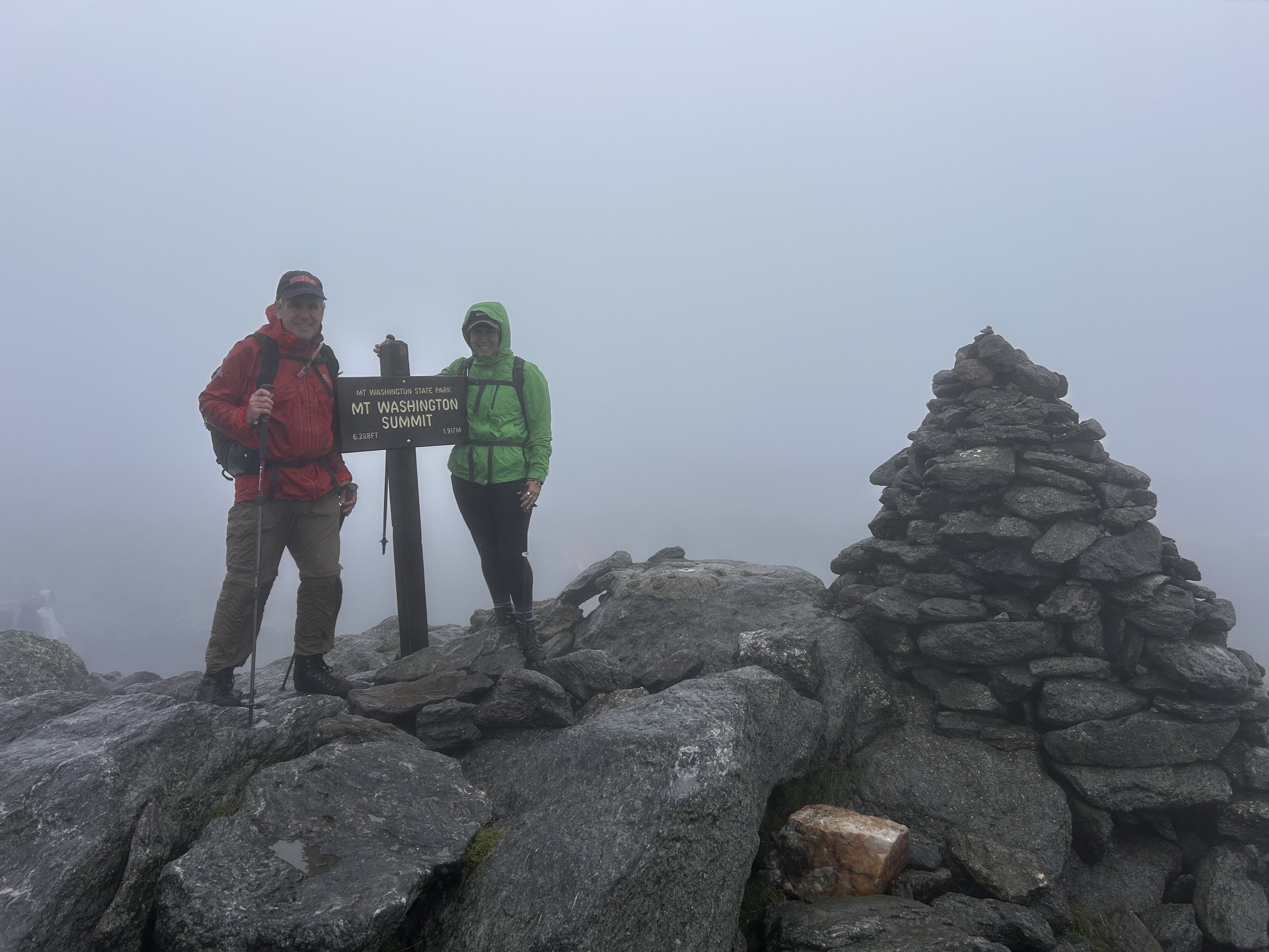
Washington
On we went to the big one! I had spied to Cog Railway before it started raining too badly while I was on Clay, but from here we could only hear the horn every so often. Then out of nowhere the track materialized in front of me! We kept on heading up, slip sliding on rocks, keeping our heads tucked from rain and wind. A sign materialized welcoming us to the Great Gulf Wilderness and we knew we were almost there! 20 minutes later at 12:17 PM (after waiting in line behind Cog Railway riders), we got our summit selfie with the Mount Washington Summit sign and cairn. It was a bit weird to be up there with “normal” people wearing flip flops who hadn’t just been fighting the elements - many of them assured us that “we normally hike, just not today” as if we were judging them… In fact I was mostly jealous that they looked warm and didn’t have another half day of walking ahead of them.
In we went to the snack bar, got a bowl of chili, two hot dogs, two bags of chips, and two body armors. Our hands were too cold and wet to open the condiments so the handy Leatherman came out to do it. It was quite a bit warmer in the building than outside, but both of us were shivering due to being wet, cold, and lack of calories - something I was very familiar with from my Mongol Derby experience. There was a distinct wish to just buy a ticket down, but then all our work would have been for naught! 4ks don’t count if you dont go up AND down under your own steam, so none would have counted! And while the weather wasn’t great, after Washington it was supposed to get easier, and no thunderstorms were on the horizon. I promised Dad he’d feel better once we got moving and we only had 1.5 miles to the Lake of the Clouds hut, so off we went around 1:10 PM. We’d layered up including our gloves and were both still shivering. I did try to dry off my leggings a bit even though the hand dryer in the bathroom says DO NOT DRY CLOTHES but I wasn’t holding up a line so I figured it was fine.
The weather did break on the other side of Washington thank GOODNESS. We got a peek of the beautiful mountains and could see the hut the whole time. I got a pretty pictures of one of the lakes up there before we went inside the hut to make a game plan. LOTC was where the easiest escape points were if we weren’t feeling it, and we also wanted to check the weather and fill waters. We were moving a bit slower than we’d talked about with my mom, our pick up driver, and I also wanted to check in about how Dad was feeling. I knew more of what we were in for going into this than he did, and he’d seemed a bit demoralized in the morning. We’d agreed we would make it to this hut, weather permitting, and then reassess. I wanted to continue, but was not going to push it if he was not feeling up to it.
Regroup
We talked through the exit points - we could go now down Ammonnoosuc Ravine Trail to the Marshfield Base Station for a pickup, bag Monroe and then exit on that trail, continue past Monroe to Eisenhower and take the Edmands path out to Mt. Clinton Road, or continue to Pierce and complete the Classic Traverse and take the Crawford Path out to the Highland Center. We had nixed the idea of adding Jackson for the “full/extended” traverse as we were moving too slowly and didn’t feel like a) hiking down in the dark and b) making Mom wait around that long for us when we had a nice hotel to get to and a lovely dinner to eat. We estimated the next 7 miles would take us about 5 hours at 40 minutes a mile, so we’d be out around 7 PM if we got moving right then (it was a bit after 2PM). We agreed to the plan and the potential exits, messaged Mom from the inReach, and off we went. The weather had gotten worse again so coats stayed on. I thankfully have a coat that keeps me warm even when wet, and wore that i instead of my raincoat which worked for me.
South Presidentials
Monroe was a quick ascent from the hut - 370 feet over .4 miles or so and we bagged it at 2:37 PM (27/38). There were a weird amount of flies buzzing around up there in the rain. There was also a large group of people at the summit having a grand old time, and we wanted to get ahead of them and jetted on out of there. We’d noticed a side trail to skip “Little Monroe” to save our legs, so we took that back to Crawford Path (AT). Continued motoring on 1.5 miles to the Eisenhower loop which we ascended and bagged around 4 PM, a little more than 12 hours after we started hiking. We ran into a group of Quebecois teens backpacking who were surprisingly fast with all that gear. The summit of Eisenhower is flat with a circle of stones, a flat path around the circle, and then a bunch of stones in the middle. Sort of weird - no cairn. We obviously could see nothing so no idea about the views, but we weren’t dallying at this point and off we went.
Down the Eisenhower loop, back to Crawford, another 1.5 to the spur for Pierce. At this point the hiking was much easier - less rock scrambling, more trees to break the wind. Still slippery and we still had our poles out. Our bodies were very tired and many muscles were very unhappy with our choices so better safe than sorry in the stability department. An hour after bagging Eisenhower we got to the summit of Pierce, snapped a few selfies with the cairn (29/40!) and off we went. Turns out we went past the summit cairn and took pictures with the next cairn, but whatever, we summitted. We couldn’t see anything due to the weather, so no views anyway. At this point we had only the trail out left, which was a bit over 3 miles, and still felt like our 7 PM estimate was correct, so we messaged Mom from the inReach and off we went.
Success!
Right before 6 PM, when we saw the sign for 1.5 miles to the Crawford Connector, meaning we had 1.7 miles left, we broke out the Advil - my IT bands were very unhappy with my choice of activity for the day and my shoulders were aching from using my poles. We were both happier after that kicked in. I saw the big sign for Crawford Path right at 7 PM, and we came out of the woods to the Highland Center at 7:02! We had done it!
Mom was there with Lyra (my dog) to pick us up and drive us the half hour back to our car at the beginning of the path. From there we went to the Mountain View Grand resort, showered (we were VERY cold), and went to the bar for a celebratory drink and some delicious dinner. We crawled into bed feeling very accomplished and slightly shocked at the whole thing.